Getting your Trinity Audio player ready...
Researchers at the University of Haifa School of Marine Sciences, in collaboration with the Israel Antiquities Authority, have uncovered evidence of a tsunami deposit along the Caesarea Maritima coastline, which could help scientists both understand how the region reacted to past natural disasters and predict future outcomes.
More stories:
In a paper led by National Geographic Explorer Dr. Beverly Goodman Tchernov and Charles J. Everhardt IV of the University of Haifa in the Geosciences journal, the researchers outline evidence of a tsunami that coincided with a powerful inland earthquake in 749 A.D. along the Dead Sea Fault, which caused well-documented damage throughout the Levant at the time.
3 View gallery


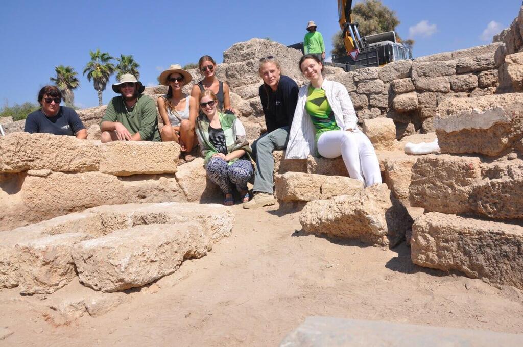
Beverly Goodman Tchernov (second from right) and her team of researchers pose at a site along the Caesarea Maritima coastline where they believe housed evidence of a tsunami deposit
(Photo: University of Haifa)
While researchers initially examined the area in the 1990s, the project was reopened by the Israel Antiquities Authority (IAA) with support from the Caesarea Development Corporation in 2016 as part of current park renovations.
The aim of the study was to determine if these 8th-century sand deposits across the site were preserved tsunami deposits. This was approached using multi-proxy analysis and comparison to characteristics of local sediments representing a wide assortment of local environments, processes affecting animal and plant remains as they become fossilized, and conditions.
After a thorough process of elimination, researchers concluded that the samples were most likely derived from a tsunami deposit. Excavation of the area was performed manually with IAA archaeologists and a supervised work crew while Haifa researchers extracted specialized cores and samples.
“This study recognizes how coastal sites suffer from earthquakes and tsunamis. In the past 10-15 years, we’ve come to understand that tsunamis pose more of a risk than we were originally aware of. This study is the first published evidence of a tsunami deposit on land at the site,” Dr. Goodman Tchernov said.
This discovery could contribute to a broader understanding of tsunami dynamics, tsunami deposit preservation, and the overall history of the Caesarea Maritima, as modern, historical, and paleotsunami deposits are critical for guiding coastal disaster management and risk assessment.
Coastal archaeological sites have the potential to reveal integrated anthropogenic and natural deposits, among them traces from past tsunamis. Not only can this improve the accuracy of the tsunami record, it also offers a glimpse into the human responses to so-called “natural” disasters. Yet at present, tsunami deposits reported in coastal archaeological sites worldwide number only in the few dozen, making this study unique.
“This study gives us very important data points for potential tsunamis that will arrive in the future,” said Dr. Goodman Tchernov, Scientific Director of the University of Haifa’s Azrieli Marine Geohazards and Climate Solutions Hub. “It informs us about potential risks and what we need to be prepared for. By examining a portion of the remains of a disaster of the past, it gives us a better sense of where the risk zones along the coast are.”
Dr. Goodman Tchernov recommended that scientists proceed to advise local authorities on coastal management decisions.
“Once we know the level of risk an area has, we can make good decisions as to what structures are kept there. This will help with decisions moving forward, like, for example, not putting daycares and hospitals in high-risk areas. It also reinforces our ability to explain why tsunamis should be part of disaster management and emergency response plans in Israel,” she said.
The tsunami deposit in question was found in what was thought to be an ancient warehouse that remained in use most likely until the 8th century. Discoveries within this overlying stratum include late 7th-century Aegean Imported amphorae and Umayyad cooking utensils and tableware. Above this is a destruction layer consisting of roof tiles, collapsed columns, and charcoal remains, along with fire-reddened walls. Eventually, another layer was built during the late-8th to 9th century, covering the tsunami deposit.
Researchers excavated an area that is believed to have housed a warehouse at the time. As Caesarea Maritima transitioned from a capital Byzantine city before 640 CE to a smaller early Islamic settlement from the mid-7th century onward, usage of the harbor declined further. The harbor warehouse complex eventually fell out of use during the late 7th century and was abandoned.
In 749 CE, the region was devastated by the earthquake, and while Caesarea Maritima did not bear the brunt of the impact, the tremors were strong enough to shake the warehouse complex, causing the roof to collapse and a fire to spread. This earthquake also indirectly created a tsunami that arrived from the west and entered the harbor, causing further damage to its infrastructure. Structures on the interior sides of the harbor, such as the warehouse, were particularly vulnerable to the force of the tsunami due to eddy formation — the circular movement of water, counter to a main current, causing a small whirlpool — and magnification.
In this case, tsunami damage to the area was left unremedied until several decades after the incorporation of the city into the Abbasid Caliphate (beginning 750 CE), when the deposit was merely flattened and built over during the resettlement of the area, effectively preserving the remains of the tsunami deposit.
Residents’ ability to move on and rebuild is a testament to the notion that what matters most for the future prospects of an individual city or an entire society afflicted by a “natural” cataclysm is not so much the severity of an event, but rather the capacity of the affected population to respond and recover, and the mechanisms and mitigation strategies it employs in order to do so. These mechanisms, in turn, depend on contingent webs of environmental, biological, social, political, and economic factors.


